The afternoon after walking Chichén Itzá, I rode the ADO bus further east to the Caribbean side of the Yucatán Peninsula — into the Riviera Maya. Two weeks in Mexico were drawing to a close, and the final stretch was three points: Cancún, a clear-water cenote, and the Tulum ruins.
The Caribbean coast south of Cancún is the "Riviera Maya," a roughly 130 km resort coastline running from just below Cancún down to Tulum. As recently as the 1970s this stretch was virtually empty beach. Then Mexico's FONATUR (national tourism development fund) built Cancún as a planned resort city, and resort development cascaded south from there to become Mexico's largest tourism corridor (see Encyclopædia Britannica — Cancún). Maya ruins, white-sand beaches, and thousands of natural wells coexist here in a way you don't find anywhere else in the country.
One night in Cancún's Hotel Zone
I skipped the tours and rode an ADO long-distance bus from the Mérida area into Cancún on my own. I watched the sun set on a beach in Cancún's Hotel Zone (Zona Hotelera) and slept there one night. Cancún is split between an inland old town (Centro) and an L-shaped narrow strip of sand where the hotels stand — most visitors stay on that strip, threading between Caribbean ocean on one side and an inland lagoon on the other.

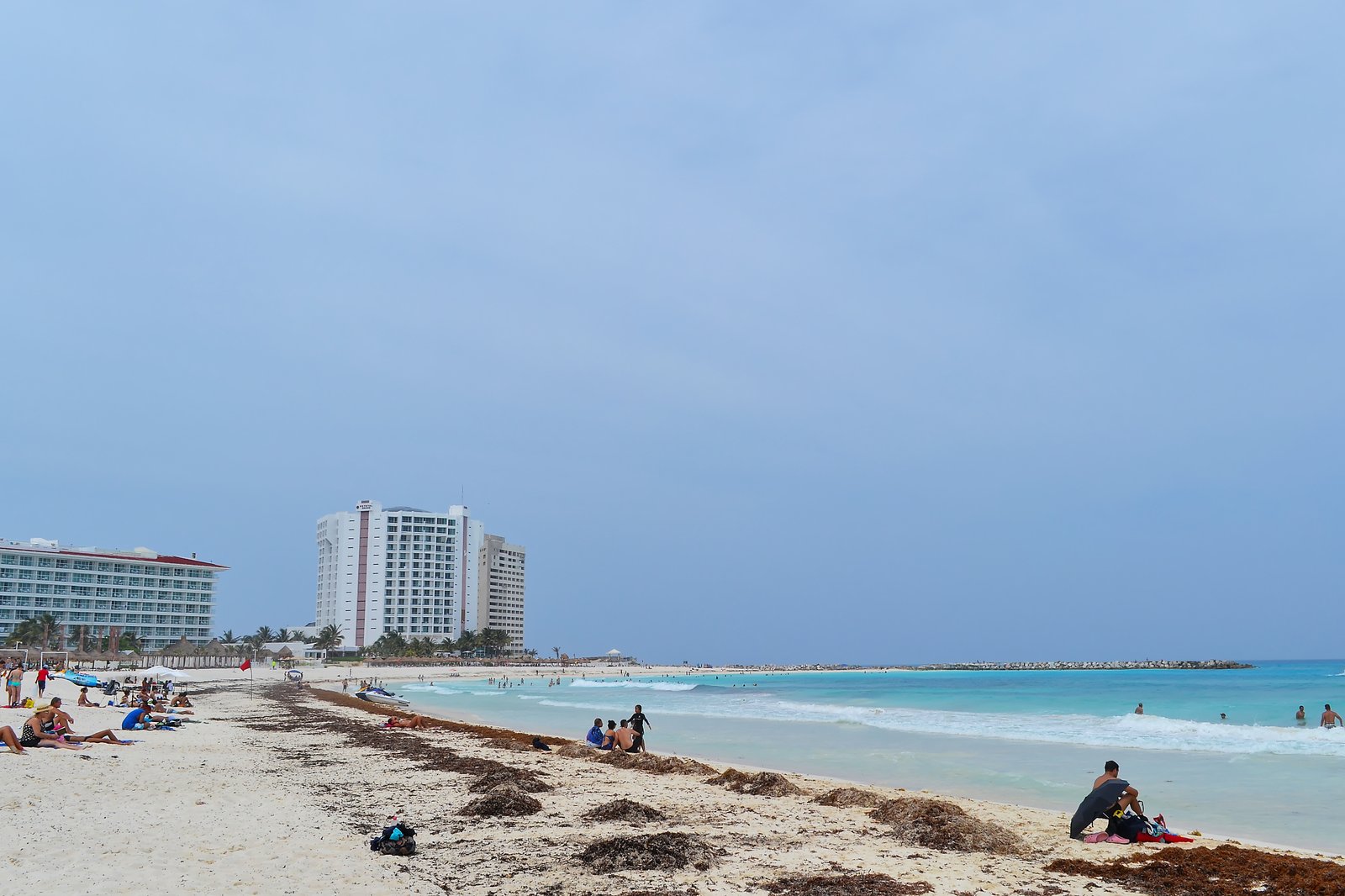
Cancún is functionally a resort-only city: actual residents live outside the Hotel Zone, around the inland bus terminal and old town. Tourism and daily life are physically separated by the geography of the city — and that spatial logic carries through the whole Riviera Maya.
A cenote where they say you can see 100 m ahead
The next morning I went south to a cenote near Tulum. The word "cenote" comes from the Maya dz'onot and refers to natural wells and cave systems formed in Yucatán's limestone bedrock as it was hollowed out by groundwater over millions of years. The Yucatán State Tourism Board reports more than 6,000 cenotes across the peninsula. They are also remarkable in geological terms: the cenotes cluster along the rim of the Chicxulub crater — the impact site of the asteroid that ended the age of dinosaurs 66 million years ago (Britannica — Chicxulub crater). They are land-features that connect directly to deep-time Earth history.
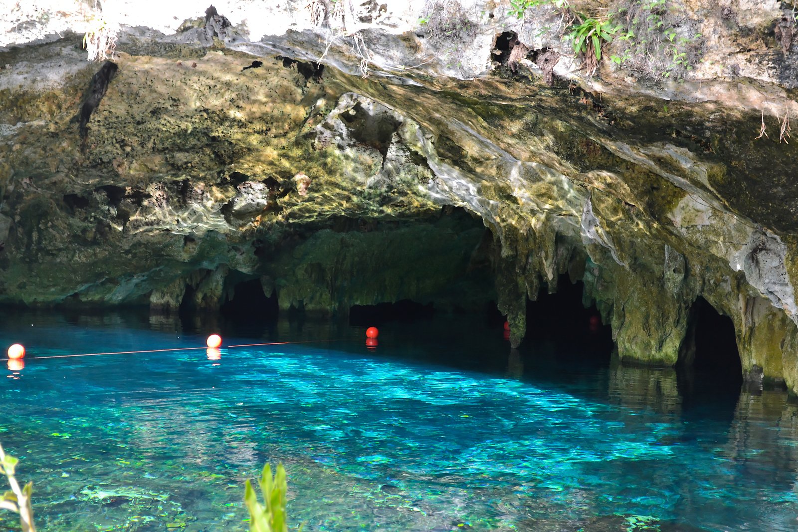
I changed and slipped in. "You can see 100 m ahead in this water," a local told me, and once I was in the water it didn't feel like an exaggeration. The groundwater was neither warm nor cold, the limestone walls dropped away into deep below me, and the blue of the water shifted with the angle of the light coming in from above. My own hand looked like a watercolor stroke under the surface. Standing there briefly understood why the ancient Maya called cenotes "the entrance to the underworld."
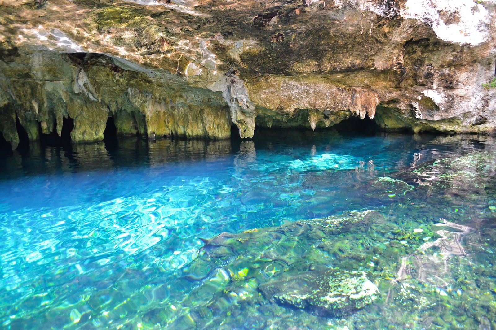
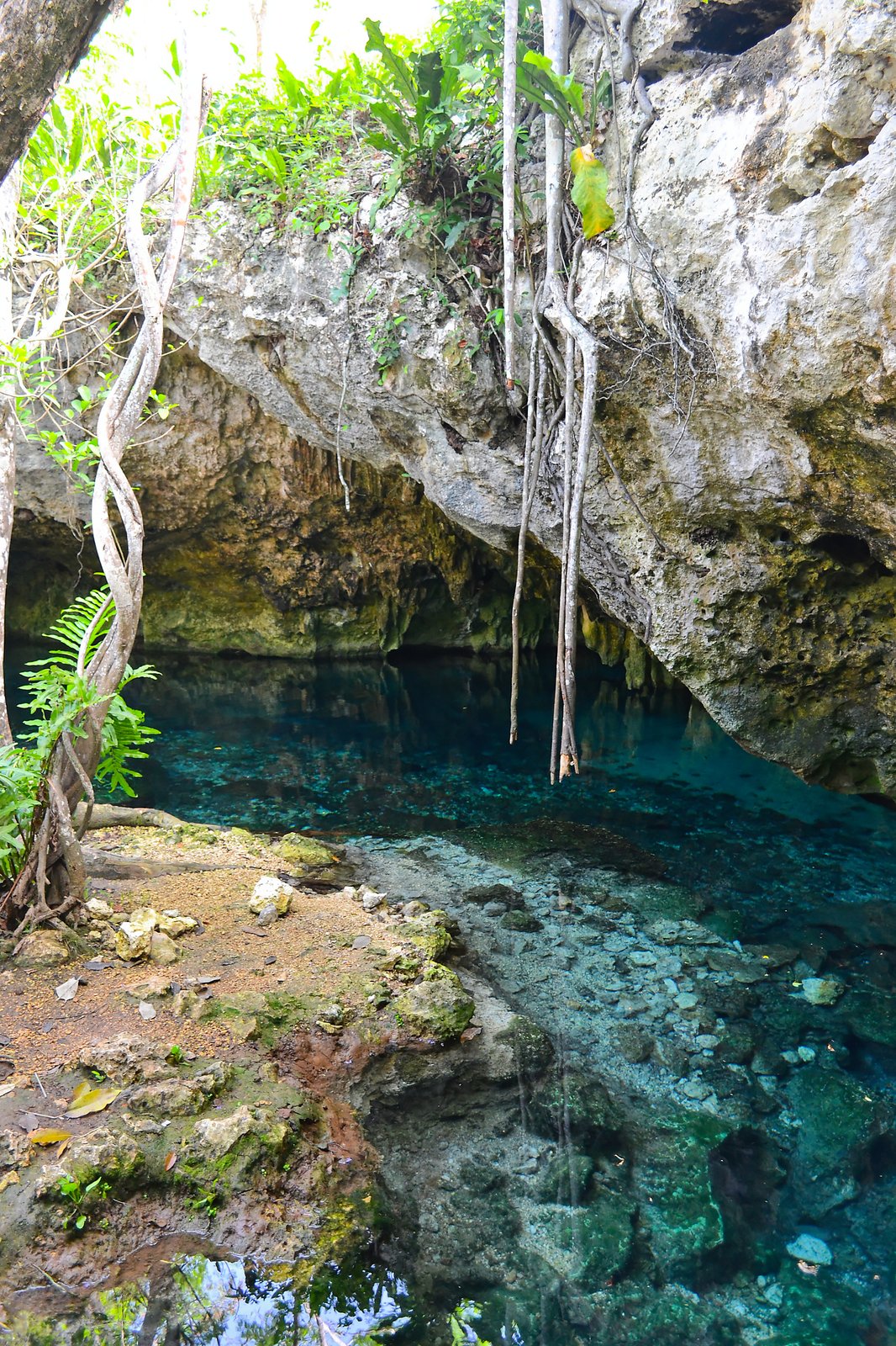
For the ancient Maya, cenotes were both a vital drinking-water source and ritual sites for offerings to the rain god Chaac, the same use we saw in Chichén Itzá's Sacred Cenote. Today they are the Riviera Maya's signature attraction — places like Gran Cenote, Dos Ojos, and Cristalino draw streams of snorkelers and cave divers every day.
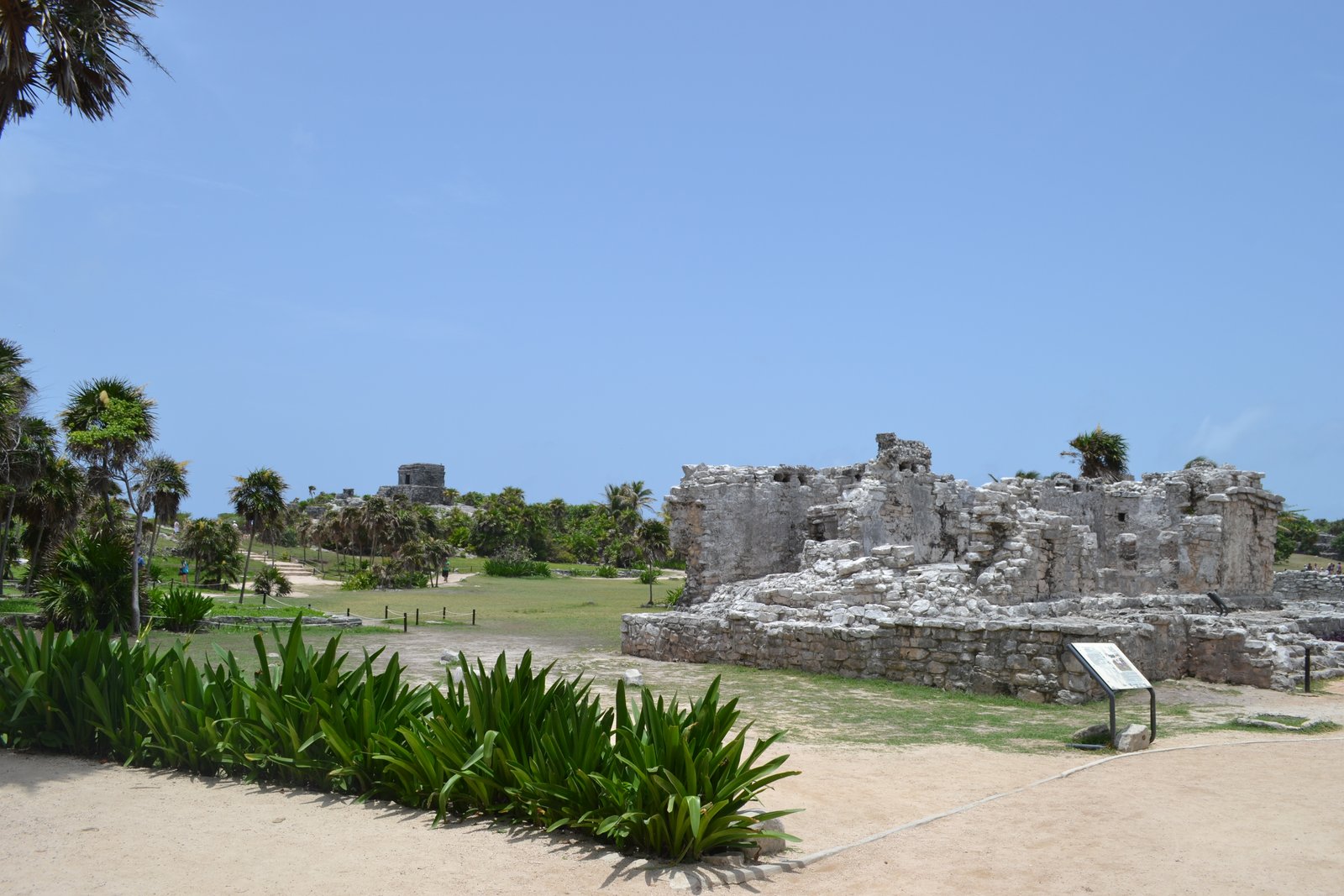
Tulum — a Maya port watching the Caribbean
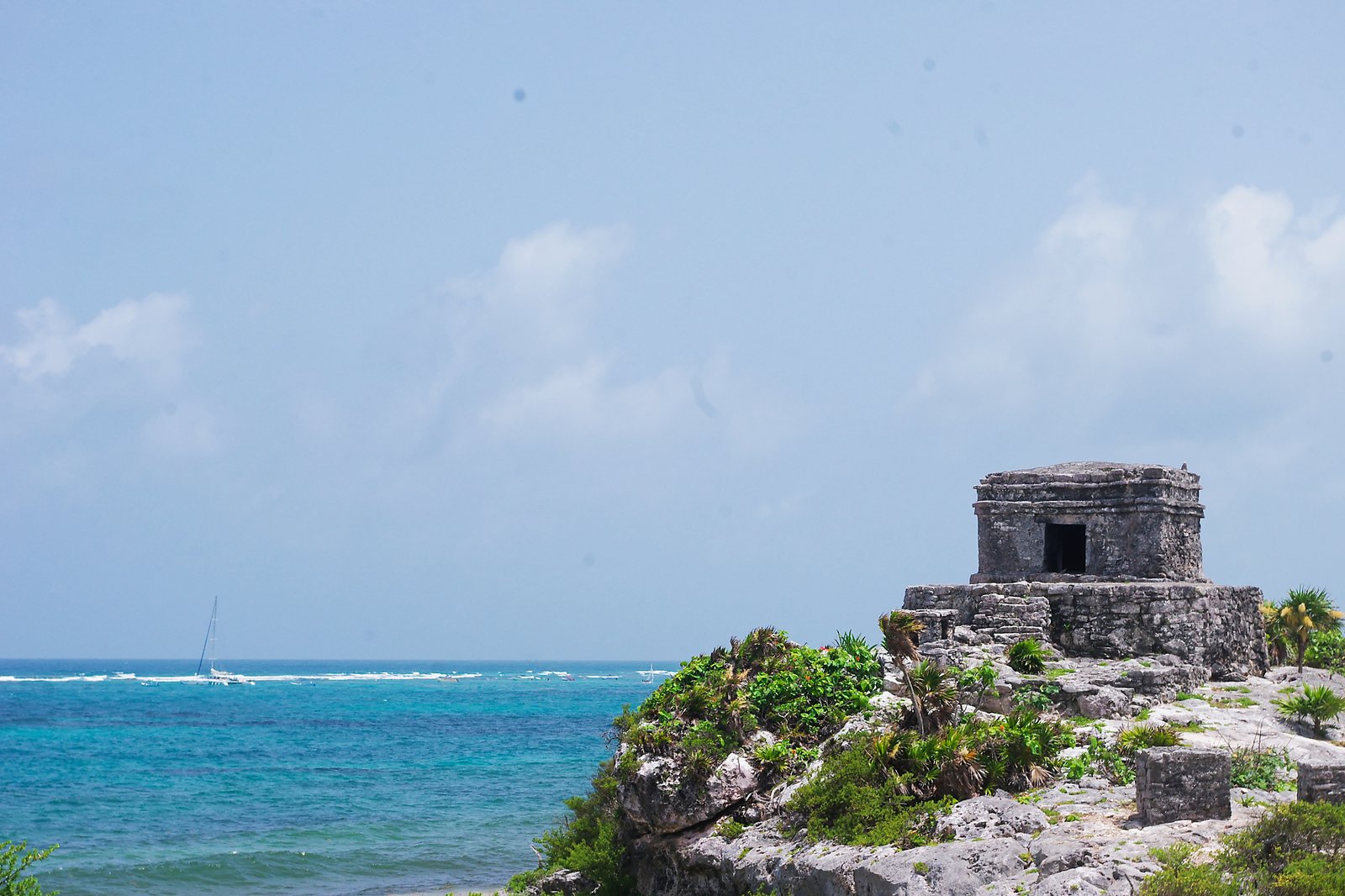
After the cenote, I headed south to Tulum, the world-famous Maya site at the southern end of the Riviera Maya. Tulum is a port-and-trade city of the Late-Postclassic period (13th–15th centuries), walled on three sides, with an east face that drops away as a cliff straight into the Caribbean — an extremely unusual location for a Maya site. Its original name is thought to have been Zama ("place of the dawn") (see INAH — Zona Arqueológica de Tulum).
Cross the site to the eastern cliff and El Castillo appears all at once, right at the edge. It's the largest building at Tulum, perched at the lip of the cliff, where the blue of the Caribbean meets the gray of limestone. This was a different kind of Maya from anything I'd seen so far — not the imperial scale of Chichén Itzá, not the geometric refinement of Uxmal's Puuc style, but a city face-to-face with the sea.
In 1518, when Juan de Grijalva's Spanish fleet sailed up Mexico's Caribbean coast, Tulum was one of the first Maya cities they saw from sea. Their log compared it to the size of Seville — actually it's much smaller, but the white-stuccoed stone buildings clearly stood out from offshore (see Encyclopædia Britannica — Tulum).
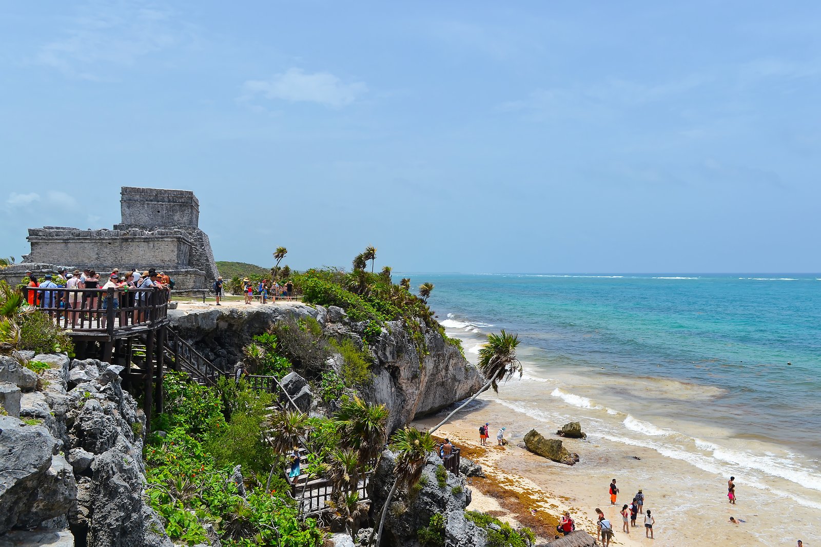
Tulum is about a tenth the size of Chichén Itzá — two hours is plenty to walk it. But the feel of the site was different from anywhere else on the trip: not jungle, not plateau, but salt air, sea wind, half the visitors walking around in swimsuits, resort and ruin sharing the same plane. The geography of the Caribbean coast made Tulum the kind of city it was — a node in the Late-Postclassic Maya maritime trade network — and you could feel that as you walked it.
Closing two weeks in Mexico
From Tulum to Cancún International Airport is about two hours by car. Two weeks of walking Mexico, since landing in Mexico City on June 19, came to a close on the flight home.
Teotihuacán's giant pyramids, Palenque in the jungle, walled Campeche, the apex Puuc-style city of Uxmal, the New Wonder of the World at Chichén Itzá, and Tulum on the Caribbean — places easily lumped together as "Mexico's ancient civilizations" turned out, on the ground, to feel completely different from each other. Not just Teotihuacán and the Maya, but within the Maya themselves: Classic vs. Postclassic, Puuc vs. Toltec-influenced, inland city vs. port city — each one ran on its own logic of architecture, population, religion, and daily life.
Maya / Mesoamerica isn't "one ancient civilization" — it was multiple cities and regional confederations running in parallel during the same era. Walking seven sites across two weeks made that clear with my body, not just in my head.
Looking out at the Caribbean from the cliffs at Tulum, it felt a little like walking the Roman world around the Mediterranean.
Places visited
Travel guide
※ Editor-supplied background based on public sources. Confirm fares and hours with the official sources before traveling.
Access
- Cancún International Airport (CUN): one of Latin America's busiest hubs. Most flights from Japan connect via the United States
- Cancún to Tulum: ADO bus, about 2 hours, around MX$300 one-way (2024)
- Cancún to cenotes: a rental car is the easiest option for an independent visit. Half-day to full-day tours are widely offered
- Tulum entrance: federal (INAH) plus state fees — total around MX$200–400
- Tulum hours: 8:00–17:00 (last entry 16:00). Going right at opening avoids both the crowds and the heat
- Sargassum (drift seaweed): tends to wash up on the Caribbean coast in large quantities between May and October. For pristine beaches, winter through spring is generally cleaner
Nearby places worth a stop
- Cobá — a Maya site deep in the jungle. The Nohoch Mul pyramid was historically climbable (check current restrictions, particularly post-2020)
- Sian Ka'an Biosphere Reserve — a UNESCO World Heritage Site (1987), with mangroves and lagoons
- Isla Mujeres — a small island off Cancún, 30 minutes by ferry. Calm beaches
- Playa del Carmen — a resort town between Cancún and Tulum, with the Quinta Avenida pedestrian zone
- Cozumel — 45 minutes by ferry from Playa del Carmen. World-class diving
References
- INAH (National Institute of Anthropology and History) — Zona Arqueológica de Tulum
- Encyclopædia Britannica — Tulum
- Encyclopædia Britannica — Cancún
- Encyclopædia Britannica — Chicxulub crater (geological context for cenote distribution)
- Yucatán State Tourism Board — Cenotes
- FONATUR (Mexico's tourism development fund) — the agency behind Cancún's planning
- Mary Ellen Miller, Maya Art and Architecture (Thames & Hudson, 2nd ed., 2014) — overview of Late-Postclassic Maya architecture
- Michael D. Coe & Stephen Houston, The Maya (Thames & Hudson, 10th ed.) — the standard, readable introduction to ancient Maya archaeology, art and religion